Thursday, August 31, 2006

Programming Note

...we interrupt regularly scheduled programming on the East Cape Trip with an administrative note. Until now, every post has been on the main page of JIINZ, going all the way back to June '05. But, with all the pictures I've been posting, it was taking quite awhile to load that main page. So that left me with three less-than-perfect options:
  1. Have readers wait for longer-than-normal periods while JIINZ loads.
  2. Reduce the amount of pictures of New Zealand.
  3. Archive old posts on other pages.
I've gone with option #3. Option #1 makes JIINZ more irritating than it needs to be. Option #2 is just downright unacceptable--it goes against the whole purpose of the blog. So that leaves Option #3. If you're interested in older posts (planning a trip to NZ and interested in finding out what to do in the South Island? want to know some good restaurants in NZ? curious about NZ's lack of religion?), click on the monthly archives on your left. Don't be shy: Go ahead, click! It's easy.

I've set the limit of posts on the main page at (I think) 25 posts. Any feedback on the new format is welcome. I'd prefer to categorize the posts by content (pictures, travel, politics, cultural differences, etc.). But I only know how to do that on Typepad, which costs money. This is Blogger, which is free, and it isn't obvious to me how to set up such categories on this software (I've actually tried, and, clearly, failed!).

ECT, Part 1


This post covers the first, and (sadly!) least eventful leg of the 
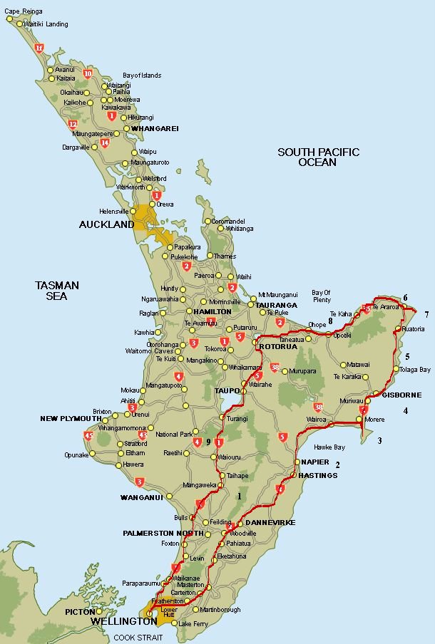
East Cape Trip. Basically, it includes the trip from Wellington to Hawke's Bay. Hawke's Bay is a region; Hawke Bay is, well, a bay. (A fine, and as far as I can tell completely unimportant, distinction.) The southern end-point of both is Napier, which is about 4 hours north-east of Wellington. To get there, you go through the Wairarapa, which is basically an inland farming and low-lying mountain region in the southern North Island.

The Wairarapa not known for being very exciting. However, as you go through its various towns, you can hit Martinborough, which is a so-so wine-tasting town (the South Island is better for oenophiles, in my not-too-informed opinion), and also Carterton, which, while otherwise unremarkable, has the Wild Oats Bakery, which one of my books billed as having the best blueberry muffin ever. As we hit town at about 9:00am, that was too good a recommendation to pass up. Assessment: it was both distinctive and delectable, though truth be told I don't know how to rank blueberry muffins.

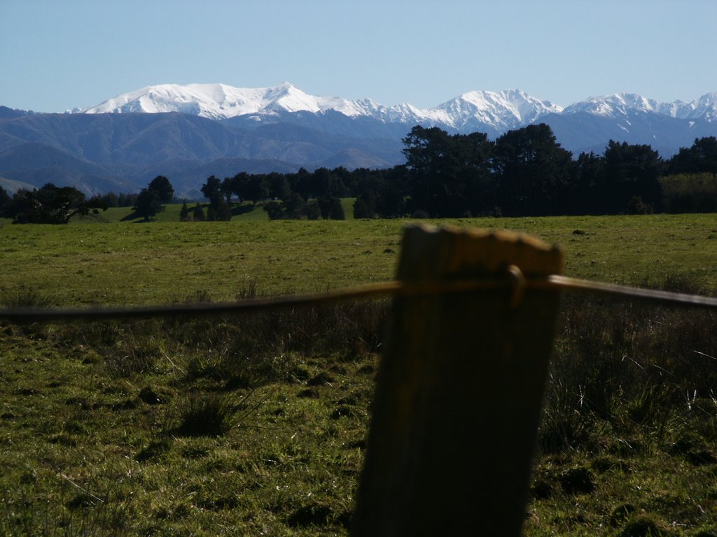
In any event, as you can see here, during winter the mountains of the Ruahine Range (point #1 on 
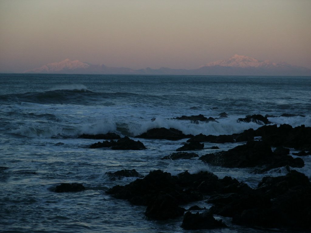
the map) are nicely dusted in snow. Before you get to Napier (point #2), you can take a short detour into Hastings, which has Te Mata Peak. That's where I took the pictures that have an elevated perspective. Pretty nice views. Finally, this post includes a picture from north of Napier, looking back on the city.

I should say this: because our goal was the East Cape, we didn't really spend much time in Hawke's Bay. But it has quite a lot to offer. Napier is the center of a bustling wine region; the bay and beaches themselves were very pretty; about an hour inland lies Lake Waikaremoana in Te Urewera National Park, both of which I'm dying to see but had to hold off for another time; and there's apparently a very nice track along the beach, in addition to a bundle of other trails and forests. Napier is also known for it's art deco architecture, though I was a bit underwhelmed by it. However, with lots of galleries, vineyards, and other distractions, I could see spending a long weekend there and staying busy the whole time. Finally, Napier is the launch pad to Cape Kidnappers, which supposedly includes a great gannett colony and rugged scenery. Not to mention New Zealand's answer to Bandon Dunes and Pebble Beach. Saving that for another trip!

East Cape Trip


One of the most rugged and uninhabited places in New Zealand is actually reasonably accessible from Auckland: the East Cape. Yet almost nobody goes there. Nobody lives there. It doesn't have many places to eat or stay, other than the occasional farmstay and backpackers. And there are basically no tourist attractions. Travellers and Kiwis alike tend to avoid it, apparently only because it's a bit out of the way as you're travelling in a rough north-south line between Auckland, Taupo, and Wellington.

All of which is to say that there's not much to do, other than see some ridiculously spectactular landscapes and seascapes. It's a fantastic place to visit, especially if it's sunny.

New arrival Jesse and I did it over a 48-hour marathon road trip earlier this week (we're on Spring Break here). We had a great time; while almost all of our time was spent in the car, the scenery was gorgeous, as were some places that we visited only as unintended-but-foreseen side effects of making a roundtrip between Wellington and the East Cape.

Pictures and descriptions to come. In the meantime, here's a map, with noteworthy points indicated numerically. If you're keeping score at home, the East Cape proper is only the bit between Gisborne (#4) and Ohope (#8). Other regions driven through include the surprisingly beautiful Hawke's Bay (#2), the perfectly snowy Tongariro National Park (#9), and the Wairarapa and Kapiti Coast (the coastal and inland regions closer to Welly in the south).

Sunday, August 13, 2006

Makara


Just outside of Wellington is a town called Makara. I've often been very close to it, as it's only about 10 minutes past my golf course. But I never got all the way there, for one reason or another. Then I learned that there's a nice hike there. So last weekend Jesse and I went to visit. Very nice place. The drive in tracks along a picturesque creek (though not so picturesque that I have any pictures here!), and then we took the long way back, through Johnsonville, which winds you through a very nice forest.

But the highlight is the hike at Makara. It is supposed to go along the beach halfway, and then the other half loops back up along the cliffs. I was looking forward to the views from the cliffs, but that part of the hike is closed for a couple months. Why, you ask? Well, apparently they need it for "lambing." That is, letting lamb graze, I take it. Definitely an only-in-New-Zealand thing, that one. Oh well, it gives me an excuse to go back in summer.

Until then, here are some pictures from the beach half of the walk. Other than the scenery, which was fantastic, you'll notice a disturbingly windswept version of myself, and one of the many likable birds that is unique to NZ. I haven't talked about the birds here very much, but if you're a birder, here and Australia are fantastic. Very strange, cool birds.

More Wellington Pictures


NZ in general is fairly environmentally conscious. One of the ways that Wellington picks up on this value is by having a nice series of nature preserves and hiking trails that more or less ring the city. Imagine that Griffith Park circled LA, or Forest Park wrapped around all of Portland (Central Park around Manhattan, etc.), breaking here and there for some spots for roads and housing to funnel through. This weekend, my friends Diana, Jesse, and I did a couple-mile section of the City-to-Sea walkway, which is part of this green-belt. Here are some pictures (once again, the South Island is what you're seeing in the distance).

Thursday, August 10, 2006

More South Island Pictures


Just some more takes on the same scene. Makara (West of Wellington, on the Tasman Sea) coming next....

Sunday, August 06, 2006

Some South Island Pictures


So, as promised, here are some pictures of New Zealand's South Island. These are taken from a stretch of south-facing coast here in Wellington (the southern tip of the North Island), between Lyall and Island Bays. They were taken at sunrise. I might put up a couple of these posts, just because they're kinda cool. Following that will be a post from Makara, where we finally had some winter warmth yesterday. It's the east/nor-east facing part of the southern tip of the North Island. Anyway, here's the South Island at sunrise.

Because of the distances involved, it's probably more important than ever to click for the larger versions. And if you use Mozilla Firefox, click again to enlarge them even more.

Saturday, August 05, 2006

Research, and some Wellington pictures


So not much is new 'round here these days. Lots and lotsa work. On that front, here's some good news: in all likelihood, I have a sabbatical coming next year! It still has to go through final vetting (I have to set up an itinerary, etc.), but it looks like a done deal. One of the many ways in which this job is excellent.

The "normal" (in the prescriptive sense) way of doing things in academia is to work a job for anywhere from 3-6 years, and then get research leave for about 6 months. Because so many of us have to work our way up and out of one-years these days, that often ends up translating into 9-12 years before you get a sabbatical. Which, of course, just means that you're further behind the privileged few who end up getting desirable tenure-track jobs from the get-go and are able to do it in 3-6 years, thereby getting a research jump on their peers and appearing more talented or hard-working than those peers.

Anyway, the nice thing about this job is that you get a sabbatical every 3 years. (Oxy was the same, as are many small, private schools; and many other schools give junior hires a sabbatical after 3 years, after which point it then goes to a larger number, such as every 6 years.) For various reasons, such as not wanting too many people on research leave after my 3rd year, I'm going early, after two years. So, just by coincidence, my situation down here means that I'll end up with a sabbatical after being in the profession for...6 years! Not too shabby.

And, for your viewing pleasure, some pictures of Wellington. The first two are taken from the top of the stairs that I head down when I go (gasp!) jogging along the harbour. Show up on that walkway on a warm-ish sunny day, and it will be teeming with people. The close-up is of the Rimutaka (sp?) mountains, which now have snow on them. The third picture is from sunrise at Lyall Bay, one of the few surf spots in town. I was up early that day and went to take some pictures of the South Island, and I got the sunrise as a bonus. Those South Isl. pictures will be coming soon. The last pic here is one teaser of what's to come on that front.

Don't forget: click on the pics for larger shots.